
NAVIGATION & ROUTE SELECTION
The Essence of Being a Responsible Boater
What do you choose as a course or route to meet your goals of safety, adventure and opportunities given the groups’ abilities, the varying environmental factors, and equipment limitations? What about dangers, safety spots, escape routes that lie ahead? Where are the unwanted wave shapes, how do you use the tides, avoid the traffic? What might the afternoon’s wind do to the sea state? Where are the play areas, and how will they change during your session? How do you get home in the fog, especially on a thick dark night?
"The secret to not getting lost is to always know where you are."
Primary factors to consider
- Wind & Waves
- Tides & Currents
- Races & Overfalls
- Chart & Compass
- Weather Systems
- Potential dangers, exposures
- Safety spots & zones
- Equipment limitations
- Personal abilities and strengths
- Island ethics
You can't do much on the water where its "seat of the pants".
Course and other info best plotted before departing. Plot course lines, compute current info. Determine and label compass headings for each leg of the course. Scale off miles. Draw out your ranges. Mark potential useful ranges - to monitor progress, check position, set danger headings. Info on tides and currents needs be plotted. Anticipate drift. Notice water depth over reefs and mudflats and probable wave structure in channels.
DEAD RECKONING or PILOTING
Dead Reckoning
The intended or assumed path through water. Plotted as a line on chart. Based on a course and speed. Mathematical.
Piloting
Navigation as art. Use of all available information, developing a navigator's eye. i.e. chart, wind, waves, weather landmarks, buoyage.
Goal: to navigate from your boat's deck, even in thick fog or dark cloudy night.
Session I - The Basics
Goals & Purpose
The 3 Primary “Uses of a Compass” that will take you all-the-way-around Earth.
- Orienting the chart.
- Taking a Bearing.
- Using Compass as a protractor
Judgment. Skill. Knowledge. Experience.
Parts of a compass
- Base, dial needle.
Parts of a chart/map
- NOAA Chart No 1
- Notice the shoreline, cliffs, bars, deep channels, ship routes, buoys, exposure, amount of water flowing.
- Latitude, Longitude.
- True, Magnetic and Grid North & Compass rose.
- Scale on chart
- Scale 1:62,500 = 15 minute. 1” = 1 mile.
- 1:24,000 = 7.5 minute. 2.5” = 1 mile.
- Depths in fathoms, feet or meters.
- Composition of shore material.
- Locations of reefs, wash rocks, major tide rips & some hazards.
- Scale
- Estimating Distance, size. Perspective.
Grid system on Earth. Demo.
Right angles, 45°, 30°.
- On paper. Draw circle, half, quarter. 30/60/90 degrees.
Measuring distance
- 1 degree of latitude
- Find your local test mile
- Dividers, string
Knowing your speed
- Known distance and time.
- Experiment until you can ‘feel’ your speed based on your paddle stroke power.
4 seconds to traverse a buoy in an 18’ boat = 3mph = 2.6 knots
Many social groups paddle around 2, (irregular stops, corrective strokes, etc.)
V = D/T Your speed = a measured distance divided by the time to paddle that distance.
D = VxT/60 The distance traveled = your speed X the amount of time you've been paddling.
Wind & your boat - rudder, skeg.
Currents & your boat – seaweeds, lobster buoys.
TERMS
- Heading: direction boat pointed
- Course: direction want to go
- Bearing: direction to a landmark. 1 of 360 degrees.
ACCURACY
- One degree of error is 92 ft in a mile (100 feet in a nautical mile)
- Ten degrees of error is therefore 920 feet in a mile (1,000 feet in a nautical mile)
AIMING OFF
- "Put Something in the bank"
TRIANGULATION
- The use of multiple bearings to give you probable location.
RANGES
Navigational Ranges: A Line of Position. Objects lining up such as a tall tree behind a boat at anchor, or a house with a steeple behind it, any two stationery things. These are the most important and most used tools in small boating, a kayaker’s primary navigational aid in current or winds as well as assisting in your location. Is an approaching boat passing off our bow? Our stern? Or are we on a collision course?
Magnetic Pole
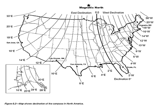
Magnetic Pole
Article on its movement: https://www.thebrighterside.news/post/earths-magnetic-field-failed-41000-years-ago-forever-changing-human-evolution/
Use of a prepped chart.
Session II - Seeing your little Route within the big Ocean
Review of Session I
Visualizing wind and its effects
- Where from
- Direction. Velocity, Fetch, Duration
Swell Energy: a Fun and Fear factor
- MIKCo’s 8 second guideline
Visualizing tidal current streams and effects
- Where to
- Rule of Thirds, and 12th's
Primary & Secondary stations for tides & currents
Separate tide stage from current direction & speed. Seeing the bigger picture.
Charts
- Casco Bay
- Fort Popham
- West Chop, Martha’s Vineyard
- Reversing Falls
Session III - Other Environmental Variables
Develop realistic Beaufort scale for yourself.
USCG / NCAR, National Weather Service weather levels
- Small Craft Advisory/Warning. Sustained winds > 22 knots, or gusts > 25 knots, or seas > 10 ft.
- Gale Warning. Winds 34 – 47 knots.
- Tropical Storm. 55 – 73 knots.
- Hurricane. 7.4 – 112 knots.
Beaufort wind scale. Wind speed correlation to observed sea & land conditions.
- Force 6: 25 - 31 mph
- Force 7: 32 – 38 mph
- Force 8-9: 39 – 54 mph Gale
- Force 10 – 11: 55 – 73 mph Storm
- Force 12 – 13: 74 – 112 mph Hurricane
- Greater than 112: Hurricane scale, - Category 1, 2, etc.
Determining Tidal Flood & Ebb, max and slack
- Use of tide and current books & data
Clouds, Fog, Dew Point
- At least discern low level, stratus, cumulus, high level ice crystals.
- Dew Point is that air temp level where that air mass will be fully saturated (100 %) as water vapor condenses into liquid water and extrudes out into visible cloud or fog as that air mass cools to its dew point.
Lightning & the 30 – 30 Rule
- Two general types – cold front and storm cell.
- Five (5) seconds per mile away.
- So if you count 30 seconds, that storm cell is 6 miles away (perhaps enough). General guideline, stay in chosen save location for 30 minutes after last thunder is heard.
- What are exposed and safer areas on land.
Determining Tidal Flood & Ebb, max and slack
- Use of tide and current books/data.
- Use attached US Harbor’s Portland Tides data, May 2025.
Session IV - Passage Plan of a trip you’d like to take in, maybe in the Gulf of Maine.
Nav Books
- Sea Kayak Navigation, A Practical Manual, by Franco Ferrero
- A Sea Kayakers Navigation Primer, by Ray Killen
- Chart #1
Tools
- Globe w Lat n Long
- Dividers
- Parallel Rule
- Hand compasses
- Boat compasses
- Nav Aid
- String
- Prepped chart
- Grease pen